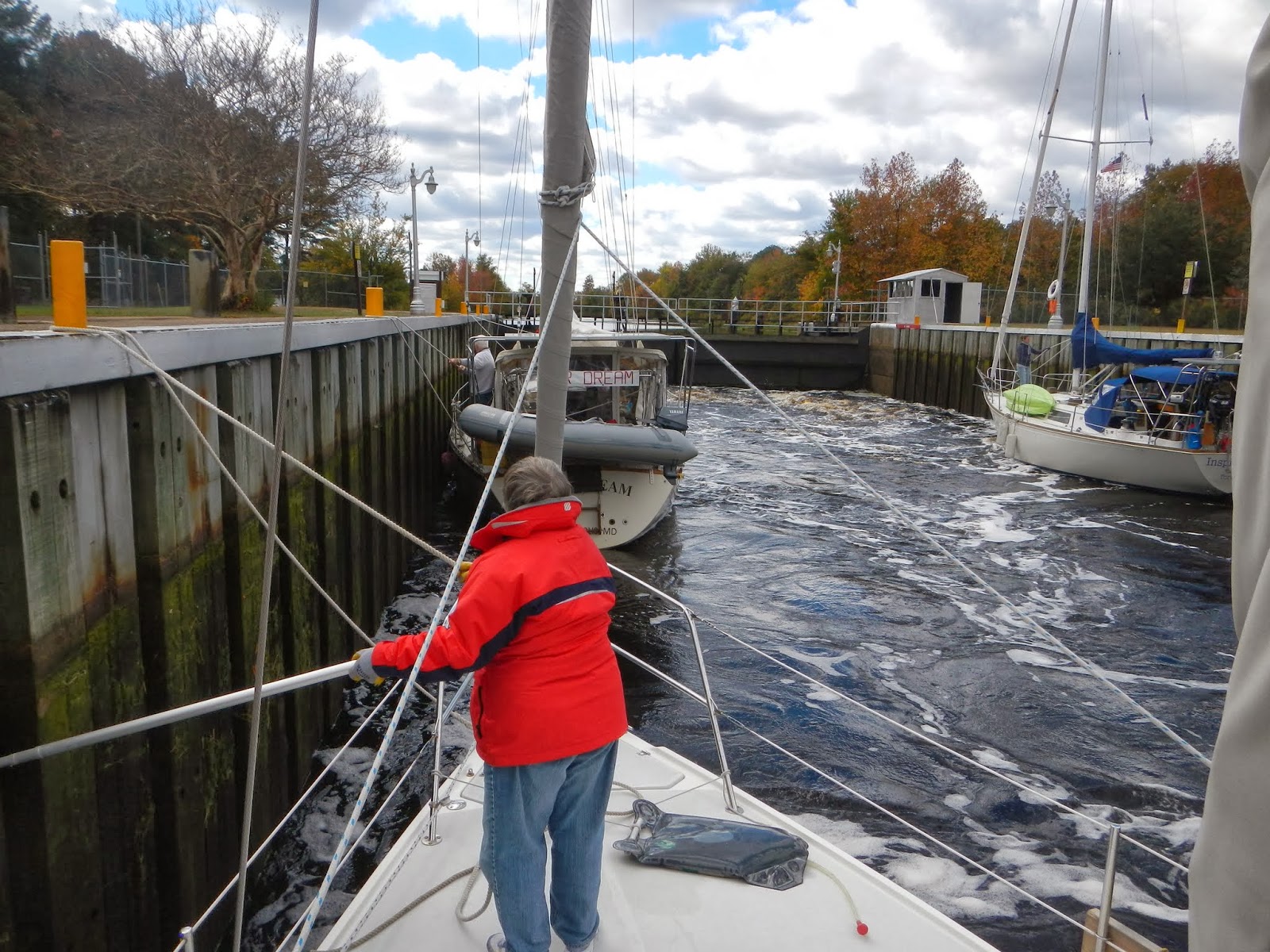
Dismal Swamp (11/3, Sunday)
Since we missed the Gilmerton Bridge
opening and had to wait and hour for it to open again, we would now
miss the 11:00 AM lock up into the Dismal Swamp. The lock runs three
times a day and the next opening is at 2:00 PM. After we finally get
passed the bridge we take a hard right turn for the Dismal Swamp and
figure we will miss the 11:00 AM opening and tie up until 2:00
PM. A fast moving Catamaran passed us heading for the lock. He
radios ahead and lets the lock master know we are trailing behind.
They delay closing the lock for us. Normally I nearly drift into the
locks avoiding any kind of significant forward momentum. Linda urges
me to keep up the speed since there are boats on both walls of the
lock waiting for us. I come into the lock with way too much momentum
and putting engine into reverse is not slowing us down enough to
avoid colliding into the boat tied up to the wall in front of us. I
rev up the engine to full speed reverse and watch the gap between us
and the next boat closing fast. This is not going to be good. I hand
the lock tender one of our ropes and our speed finally drops. We stop
with in 10 feet from our near target, with the engine still at full
speed reverse. I quickly run back take the engine out of reverse, so
we don't start backing out of the lock and promptly stall the engine.
10 minutes later the lock closes and up
we go.

Almost halfway from somewhere
We are the last boat to exit the lock and again the rest of
the boats are waiting for us because the lock tender has to get in
his car and drive to the swing bridge following the lock to open it
to let us all

past. We had a nice sunny afternoon motoring down the
straight and narrow Dismal Swamp Canal with the changing fall colors
and leaves dropping in the water.

Only slow going sailboats are on
the Dismal Swamp due to speed limitations, most power boats prefer
the Virginia Cut which is an alternate route without speed limits.

The tea colored water of the Dismal Swamp


After a couple hours we reach the North Carolina Visitors center
which is also a highway rest stop. I pull over to the dock a little
prematurely and start pruning some trees over hanging the canal, with
our rigging, now I know why that guy on the dock was waving at me.
Linda standing mid-ship gets a shower of nuts, pine needles and small
branches. We are the second boat to tie up to the dock, which is
long enough to tie up 3 or 4 cruising sailboats.

Most of the other
boats kept going to make the last lock in the Swamp. We have time to
visit the Dismal Swamp Nature center and hike some of the trails that
are on the opposite side of the canal. There is a floating bridge
across the canal, which an operator opens and closes. Normally it is
across the canal until a boat comes along.
The forecast for that evening is for
temperatures to get down near freezing. Very happy to have our
propane heater. We wake up in the morning and I quickly fire up the
heater, the interior of the boat is in the mid-40s. The boat quickly
warms up. When I go outside to take some pictures I see that our
sail cover and the roof of Visitors Center is covered with frost.

We
got up early to leave before sun up to make it to the first opening
of the last lock.

Leaving Visitors Center, floating bridge is open
First we have to wait for the swing bridge to open
before we head into the lock. Again the Bridge and Lock tender is the
same person so we wait for him to close the bridge and drive over to
the adjacent lock to operate it.
Elizabeth City (11/3 Mon & 11/4 Tue)
 Now that we are back down to “sea
level” we are truly in a swamp. Starting two hundred years ago the
first Dismal Swamp canal was dug to harvest cypress trees. The
surrounding swamp was drained as much as possible to get to the
trees, so now it is a little too dry to really be a true swamp any
more. But the canal portion that is back down to sea level is still
a true swamp since it could not be drained. Once we are through the
straight canal we enter the Pasquotank river which winds down to
Elizabeth City. By the time we reach Elizabeth City we are quite
cold and decide to forgo the free city dock and go into Pelican
Marina so we can plug in for heat. We call the Marina and the boat
ahead of us got the last available spot, so we head to the City dock.
Despite adverse winds we manage to successfully tie up to the
docks. A volunteer, a member of the “Rose Buddies” which started
back in the 80's welcoming cruisers to Elizabeth City, with roses and
a wine and cheese party in the evenings, helps us dock.
Now that we are back down to “sea
level” we are truly in a swamp. Starting two hundred years ago the
first Dismal Swamp canal was dug to harvest cypress trees. The
surrounding swamp was drained as much as possible to get to the
trees, so now it is a little too dry to really be a true swamp any
more. But the canal portion that is back down to sea level is still
a true swamp since it could not be drained. Once we are through the
straight canal we enter the Pasquotank river which winds down to
Elizabeth City. By the time we reach Elizabeth City we are quite
cold and decide to forgo the free city dock and go into Pelican
Marina so we can plug in for heat. We call the Marina and the boat
ahead of us got the last available spot, so we head to the City dock.
Despite adverse winds we manage to successfully tie up to the
docks. A volunteer, a member of the “Rose Buddies” which started
back in the 80's welcoming cruisers to Elizabeth City, with roses and
a wine and cheese party in the evenings, helps us dock.
We head over
to the visitor center. They mention that they have a wine and cheese
get together for the cruisers if they have at least five boats and it
is warm enough. Well, they have more that 5 boats, but it isn't warm
enough. We decide to stay another day since the museum I wanted to
see was closed on Monday's. The next morning Linda heads out to do
some laundry and I work on a couple boat projects. After we go to
the museum and do some food shopping and return with a very loaded
cart. We stop for dinner on the way back to the boat.


Typical sailboat exiting the Dismal Swamp with tree branch ornaments
on the spreaders.
The next morning we leave the dock
before sunrise because we have a long sail across the Albemarle
Sound.

We make it to the Alligator River (11/6 Wed) near the entrance of the
Pungo River - Alligator River Canal. This is the most remote area of
the ICW, there is no cell phone access or light pollution from
surrounding towns, The nearest road is over 10 miles away. A very
remote place. 10 or so boats anchor in the area, since it is too
late to get through the canal. That night it gets amazingly dark
without any signs of civilization. The next morning is rainy and
foggy, but relatively warm and we are through the canal by early
afternoon, when the rain stops and the fog clears. Mid-way through
the canal we hear a lot of unhappy people on channel 16 on the VHF
radio. We soon find out why. 4 or 5 large power boats in line are
coming down the canal at full speed creating tremendous wakes. They
do not slow down and ignore any requests to do so. They are all
headed south piloted by delivery captains trying to get their wealthy
client's boats from Long Island, NY to Florida ASAP, for the winter.
If I only had a paint ball gun. For the next ½ hour we hear other
boaters in front of us curse them out as they go by. By afternoon
the rain stops and we get in some sailing across the Pamlico River
and we drop anchor for the night in Campbell Creek (11/7 Thurs) just off the ICW,
another anchorage with few signs of civilization that we have all to
ourselves. The next day we get out on to the Pamlico Sound, small
craft warnings makes for a good afternoon of sailing on a broad
reach.

We decide to bypass Oriental and save that town for our return
trip. Back on the ICW we anchor in Cedar Creek (11/8 Fri) late in the
afternoon and head up as far as we can go with our 4.8 foot draft, no
other boats here. By sunset there are an additional 10 or so cruising
boats, behind us. Gertie is one of them.

Cedar Creek in the morning (Gertie)
Next morning we have a short run to
Beaufort (Bow-fort) and Morehead City. I over looked a draw bridge
just south of Town Creek so we have to wait ½ hour for the next
opening. We drop anchor on the Beaufort waterfront, launch the dinghy
and row in for lunch and a walk around the town.

Pirate ship on the Beaufort water front
Gertie missed the
channel for the backside entry to Beaufort and heads to Morehead
City. That afternoon we make a reservation for Spooners Creek
Marina (11/9 Sat) , a very protected Marina that only has room for a couple
transients. I am way off on our estimated arrival time and by the
time we get there the dock manager has left for the day. Another
cruising couple on a Catalina 34, yell over to us where we are
suppose to dock for the night. Fortunately they where there, to be
our dock hands, since we had to back into the slip which I suck at.
They give us the combinations and other details as requested by the
dock manager, before he left. Our main goal for staying here was it
is in easy walking distance to a Best Buy. Our Monitor/TV died and
we wanted to exchange it for a working one. We missed the 30 day
exchange period by a couple days, not like there are a lot of Best
Buys on the ICW. The clerk tells us it will take two weeks to get it
repaired. We tell her that won't work for obvious reasons and explain
our problem to the manager. He was very accommodating and we leave
with a new one. The next morning the dock manager tells us the
dockage is free since he was not there when we came in.
Next day we pass by Camp Lejune and the
Live Firing Area.

We anchor in Mile Hammock Bay (11/10 Sun) on the western edge
of Camo Lejune. They let boats anchor, but no going ashore. Soon
after we dropped anchor a steady line of boats come in to anchor
until dark.

Precession of boats trying to make it to the next bridge opening, on time.

Shoal area, oops
The next morning we head for Wrightsville Beach (11/11 Mon) , just
east of Wilmington, NC. Was considering staying there for two nights.
We plan to meet up with Gertie. Wrightsville Beach is a barrier
island and very popular beach resort. We all go for a long walk
along the beach on a fairly warm afternoon. There even are some kids
in the ocean swimming, no adults are in the water though. Finally
feels like we are in the south with a warm afternoon on the beach.
We find out that a cold front is forecast to come through in a day or
so and decided we don't want to be in our current anchorage with 25
knot south winds, so we leave that next morning for Cape Fear.
Fortunately we get off the Cape Fear river before the high winds
start to materialize and we get back on the ICW at Southport. We and
Gertie made reservations at St. James Plantation Marina for the
night. A very protected excavated basin off the ICW. We pass
Southport Marina with a long face dock along the ICW. The transient
docks are full with a group of Canadian boats we have been passing
back and forth for the last few weeks. Glad we did not plan to stay
there, very exposed. A couple miles past we turn into St. James.
Without a sign you would miss the entrance. Once we are in the basin
and out of the wind the temperatures seem to jump up immediately. We
entered wearing foul weather gear to block the wind and was soon in
shorts and T-shirts. Very tight fairways here tends to scare off
transients from this Marina. Even with the predicted cold and high
winds there were only 3 transient boats here. That evening we all
went out to a very good dinner at the marina resturant, which is only
part of the very large golf and retirement community of St. James
Plantation (11/12 Tues & 11/13 Wed). That evening the dock manager came by to tell us they
were turning off the water on the docks, because they were concerned
that temperatures might get down to freezing that night. It is good
to be on the dock, with heat.

St James Plantation Marina
Late that night laying in bed the rain
suddenly starts sounding harder, I mean literally harder, we are getting pelleted with sleet. I quickly look up
the weather radar to confirm, without having to pull my butt out
of bed. I lie in bed remembering how Genie Soboslai told us we would
not need to take many warm articles of clothing. I immediately email
her a screenshot of the weather radar showing snow and our position.

We are the blue dot
When we get up the next morning I find
snow on our dodger.

There is ice on some of the decks around the
marina that are not over water. Lacking sand or salt the workers put
out orange warning cones. We go to the office and sign up for
another night at the marina.
After two nights at St. James we head
towards the NC/SC boarder.
We had originally thought about anchoring
in the Calabash river, but it was too early in the day.
Interesting Factoid for old people,
“Goodnight Mrs. Calabash, wherever you are”, Jimmy Durante's sign
off to his 1950's show, has its origins from here. Although none of
the local explanations are actually true. The True Story is Durante
and his first wife had stopped here in their travels and they loved
the food at some local restaurant. Well his wife apparently, raved
about the food long after they left so he gave her the pet name Mrs.
Calabash. She died in her 40's and he later remarried. He revealed
years later after the show went off the air that it was a tribute to
his first wife.
I find out about a marina that has a
hot tub, so I decide that is the place for me, so we stop early at
the Barefoot Marina (11/14 Thu). Warmest I have been in a while. Since we are on
a face dock to the ICW we were concerned about wakes. So few boats
this time of year it was not a problem. The marina manager has a
unique way of dealing with boats that create wakes that cause damage
or problems. He calls the bridge operator just down the ICW,
requesting that they refuse to open for that specific boat until they
return to the marina and apologize and/or pay for damages.
The next morning we have a short run to
Osprey Marina (11/15 Fri & 11/16 Sat) where we will be staying for a couple days to visit
with Linda's sister and pick up a number of UPS packages. Osprey is
a real nice buck-a-foot marina, which is essentially dug out of the
swamp. I tell them we are 36 feet, I should of mentioned that we
have stuff hanging off both ends of the boat. I miss the turn into
our slip and tap boats fore and aft trying to turn the boat around.
There was not enough space to swing our probably 42 feet over water
length around without making contact.

This boat was on the gas dock and he had a hard time turning around to leave.
After three nights at Osprey we head
out. That night we anchor on the South Santee river (11/17 Sun), another
anchorage in the middle of no where. As it gets dark a light fog
descends and we are the only boat around. With a wide river and
marsh lands it was rather spooky in the fog.
The next morning we leave for
Charleston. We go most the day without seeing another boat, rather
strange. Later in the afternoon before we reach Isle of Palms,
before Charleston, which has a couple notorious shoal areas, we are
passed by a power boat. As we approach the first shoal I slow the
boat to a crawl so we are an hour or so past low tide before going
through. At the end of the shoal is a drawn bridge that does not
open between 4 and 6 PM. Low tide is around two, so we are trying to
get the maximum tide and not miss the bridge. As we are putsying
along a Canadian sailboat comes up fast and passes us, this should be
fun. He gets further that I thought, but is quickly aground in the
soft mud. As we approach we notice that the power boat that passed
us a couple hours ago is also aground, he must have been way out of
the channel. We slowly pass the Canadian, just as they manage to back
off. They drawn 5.5, we drawn 4.8. We read off the depths to them on
the radio as they decide to follow us. As we get down to 4.8 on the
depth sounder we bounce on the bottom, but still maintain our forward
speed. We tell our Canadian friend, but they still follow our track.
Looking back we see they are firmly around this time and will have to
wait at least an hour to float free. We on the other hand get lucky
and make it in time for the last bridge opening before 4 PM.

Waiting for the rising tide.
Our next hurtle is getting through
Charleston harbor without being stopped by the Coast Guard and
Homeland Security. We had a number of friends ahead of us who
complained about being boarded. As we enter Charleston harbor we see
two Coast Guard boats that are busy with a power boat. We slip by
without attracting their attention. We anchor in the Ashley River (11/18 Mon, 11/19 Tue)
just off the Charleston Municipal Marina. The next morning we head
into Charleston. We meet up with Dan and Dawn (Gertie) and take the
boat tour to Fort Sumter.

I had not realized Fort Sumter is mostly
ruins of the original Fort which was 3 stories tall prior to the
start of the Civil War. By the end of the Civil War it was a pile of
rumble. The current National Park is the excavated remains of the
lowest level of the original fort.


The following morning is windy and
overcast and we decide to leave a day sooner than originally planned.
A mile or two down the ICW from Charleston we go through the Elliot
Cut, one of the more narrow passages on the ICW. It is a short
connection between two rivers. We hit it at maximum current and it is
ripping. I feel like a salmon swimming up stream, we slow down to 3
knots. There are sizable standing waves in the cut. That evening we
anchor in another remote anchorage off the Wadmalaw River. The
Wadmalaw River is exposed to the north wind and has a pretty good
chop on it. We head up Tom Point Creek (11/20 Wed), which is rather narrow, only
wide enough for a sailboat to anchor in mid-channel, but quite
protected from the wind. Another scenic remote anchorage in marsh
land all to ourselves. The following morning we head to Beaufort, SC
and get a slip at Ladys Island Marina (11/21 Thu) for a couple days to catch up
on a couple of boat projects. At a dollar per foot this Marina is a
real bargain. When we make the reservation the marina manager tells
us to night is pork chop night at a place next door, $5.00 per
person. We call Gertie and our evening plans are made.